
PC120 Landslide Key Summary
Indicative recent quote range only.
When desktop-only and details are complete.
Suitably Qualified & Experienced Person.
What is PC120, and why is landslide risk suddenly appearing on Auckland projects?
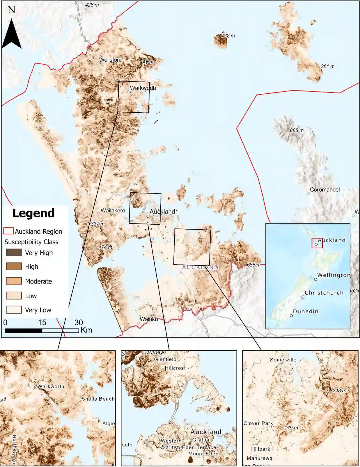
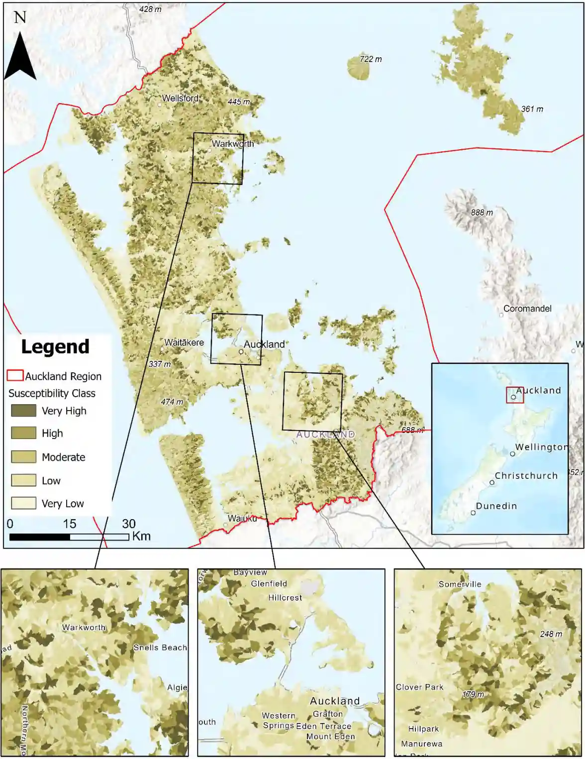
PC120 is Auckland Council’s proposed update to the Auckland Unitary Plan provisions for housing intensification and natural hazards. For landslides, the practical shift is that Council is now using newer regional susceptibility mapping and a more risk-based framework when assessing development.
This matters because the mapping is not limited to dramatic cliff sites. It can also capture land near slopes, land downslope from mapped susceptibility, and land that appears ordinary to a homeowner but is close enough to a mapped potential run-out area to trigger questions.
Susceptibility is not the same as final risk
A landslide susceptibility layer is a screening tool. It indicates where landslides may be more or less likely across a wider area. It does not automatically prove that a specific proposed extension, garage conversion, sleepout or new dwelling is unsafe. That is why a site-specific geotechnical response can be so important.
What is a Section 37 certificate, and why does it matter?
A Section 37 certificate is a warning attached to a building consent or project information memorandum when Council considers that a Resource Management Act issue affects the proposed building work. In practice, it can mean the building consent may be granted or ready to grant, but the owner cannot start the affected building work until the planning issue is resolved.
Do not ignore a Section 37 notice
If the certificate says no building work may proceed, starting work before the issue is resolved can create legal, insurance, inspection and completion problems. The correct move is to identify exactly which planning matter triggered the notice, then address it with the right professional evidence.
Real project experience
How PC120 affected our Namata Road, Onehunga building consent
On our 73 Namata Road, Onehunga project, Auckland Council attached a Section 37 certificate to the building consent process. The project included a porch renovation, a new first-floor extension, roof cladding replacement and conversion of the existing garage into a sleepout with wastewater and stormwater connections.
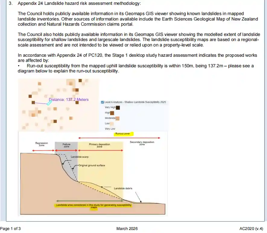
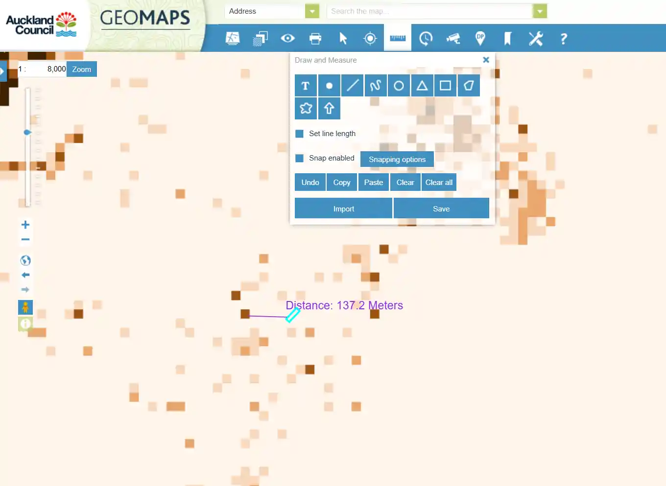
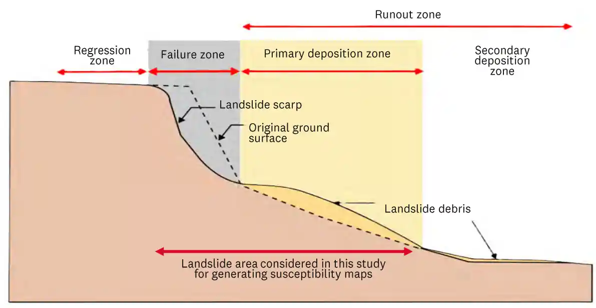
The landslide issue was triggered because Council identified run-out susceptibility from mapped uphill landslide susceptibility within 150 metres. In the Council notice, the measured distance was recorded as 137.2 metres.

Why the solution was straightforward
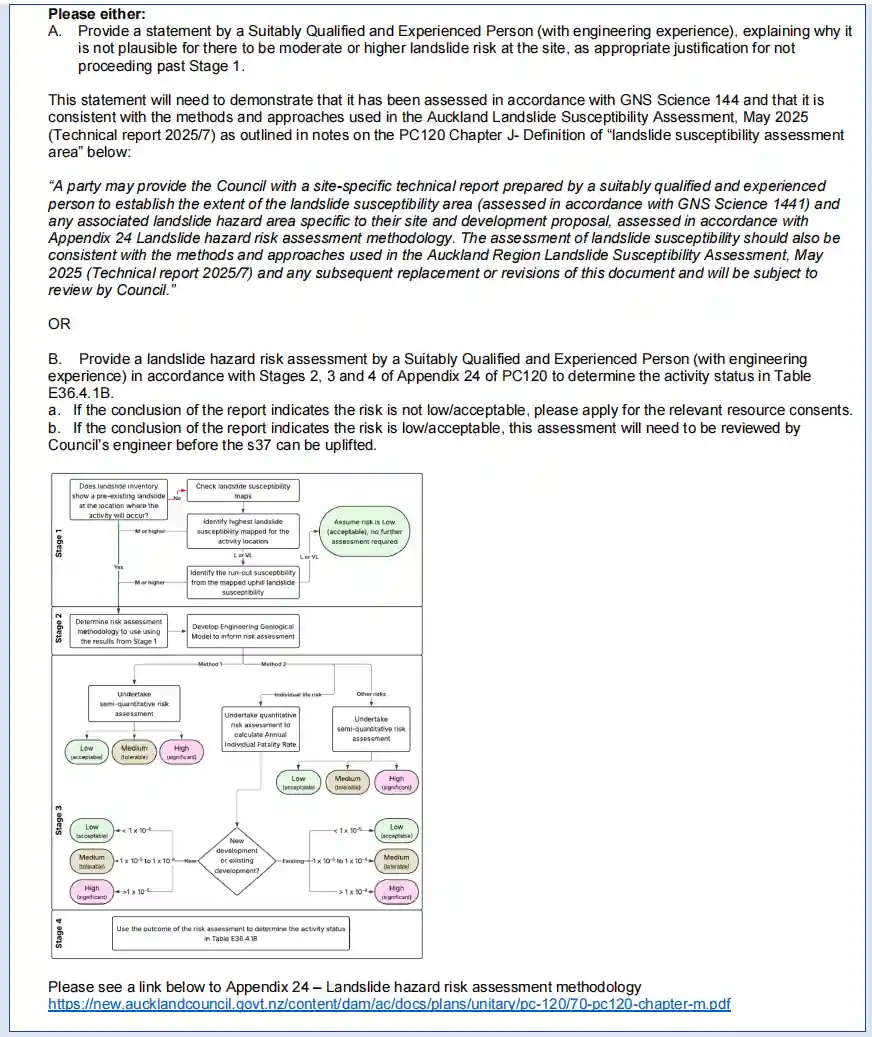
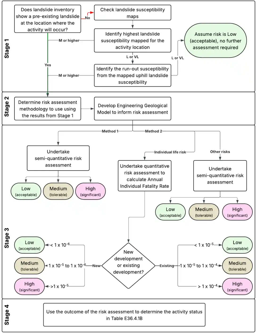
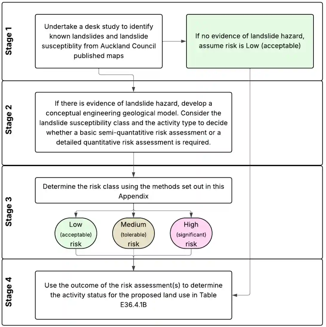
After reviewing the plans and the mapping, the geotechnical engineer quickly considered that this could be addressed as a Stage 1 response. The key reason was that the site slope and the relationship between the works and the mapped landslide source did not support a plausible moderate or higher landslide risk for the proposed building work.
We moved immediately: the specialist quote was accepted, the agreement was signed, the required plans and Council information were provided, and the Stage 1 documentation was prepared. That documentation cleared the landslide issue and allowed the building consent pathway to move forward without turning the landslide matter into a full resource consent process.
Stage 1 statement vs full landslide hazard risk assessment
The best response depends on what the mapping shows, the site topography, the proposed works, earthworks, stormwater, vegetation, retaining, loading, access and the vulnerability of the activity. A bedroom, sleepout or dwelling addition is treated differently from a driveway or minor landscape work because people may sleep or live in the building.
| Pathway | When it may fit | What is proved | Practical outcome |
|---|---|---|---|
| Stage 1 desktop statement | The mapping trigger appears broad or conservative, and the site-specific relationship does not support moderate or higher risk. | That it is not plausible for moderate or higher landslide risk to affect the site or proposed works. | Often the fastest and lowest-cost pathway if the facts support it. |
| Stages 2, 3 and 4 assessment | The site is on or below a meaningful slope, has mapped slips nearby, includes significant earthworks or the Stage 1 answer cannot safely close the issue. | The actual risk category, whether the risk is acceptable or tolerable, and what mitigation is needed. | More cost and time. May need engineering design, Council engineering review and resource consent. |
| Resource consent | The assessment identifies risk that cannot be treated as low or acceptable under the relevant rules. | That the proposal can be approved with appropriate risk management, or that the design should change. | Planning assessment, specialist evidence, Council review and a longer consent pathway. |
How much does it cost, and how long does it take?
For a straightforward Stage 1 desktop statement, the recent quotes we received were approximately NZ$600 to NZ$1,500. In simple cases, the documentation can often be ready in less than two to three working days, assuming the specialist has enough project information and the mapping issue is not complex.
That cost range should not be treated as a fixed market price. It can change depending on the geotechnical consultant, urgency, whether a site visit is needed, how much historic information exists, the quality of the architectural drawings, the slope, stormwater implications and whether Council requires review of a fuller assessment.
Usually low-cost
Clear Stage 1 desktop issue, good drawings, no major earthworks, slope relationship clearly does not support the mapped risk.
Usually higher-cost
Steep site, retaining, excavation, fill, poor drainage, historic slips, large-scale instability, new dwelling platforms or Council requests for Stages 2–4.
What should you do if Council raises PC120 landslide risk?
- 1Read the Council wording carefully.
Do not assume every natural hazard note means the same thing. Check whether Council asks for a Stage 1 statement, a full landslide hazard risk assessment, or a resource consent.
- 2Check the GeoMaps layers.
Look at shallow landslide susceptibility, large-scale landslide susceptibility and mapped landslide inventory information. The relationship between your proposed works and the mapped area matters.
- 3Confirm the proposed work clearly.
A small internal renovation may be very different from a new bedroom addition, second storey, retaining wall or new dwelling.
- 4Send the right information to a geotechnical engineer.
Provide architectural drawings, site survey if available, earthworks extent, drainage/stormwater notes, site photos and the Council notice.
- 5Respond to Council with a targeted package.
The goal is not to send more paperwork than needed. The goal is to answer the exact reason Council stopped or restricted the consent.
Documents that help the geotechnical engineer respond quickly
- A copy of the Section 37 certificate or Council RFI wording.
- Architectural plans showing the proposed works, floor levels and site relationship.
- Site plan, survey, contours or levels if available.
- GeoMaps screenshots showing the relevant landslide layers and the property boundary.
- Photos of the site, driveway, slopes, retaining walls, drainage paths and neighbouring land.
- Any previous geotechnical report, engineering report, PIM, LIM or historic consent record.
- Stormwater information, especially where roof areas, hard surfaces or overland flow may change.
How ArchSolutioNZ helps when PC120 appears during your building consent
We are not a geotechnical engineering firm, and we do not pretend that an architect should sign off landslide risk. Our role is to identify the consent problem early, coordinate the right specialist, provide the drawings and context the specialist needs, and prepare a clean response to Council.
Because we deal with Auckland Council building consent issues, RFIs, Section 37 notices and residential alterations regularly, we know when a problem needs a planner, when it needs a geotechnical engineer, when it needs a structural engineer, and when it simply needs a clear response that connects the specialist report back to the building consent.
We can coordinate
GeoMaps review, drawings, specialist brief, report coordination, Council response and follow-up.
We can reduce confusion
We translate the Council notice into practical next steps so you know whether the issue is likely minor, urgent or serious.
Common mistakes to avoid
Assuming the map is wrong
The map may be broad, but Council will still expect a professional explanation if the layer has triggered the consent issue.
Sending a generic old geotech report
Older reports may help, but Council may still need the PC120 methodology and the current proposal addressed directly.
Starting work early
A Section 37 restriction can stop the commencement of work even where the building consent documentation is otherwise advanced.
Using the wrong professional
A designer or architect can coordinate the process, but the landslide risk opinion should come from the right engineering specialist.
PC120 Landslide Risk FAQs
What is PC120 landslide risk in Auckland?
PC120 is Auckland Council's proposed plan change that updates natural hazard provisions and introduces a more risk-based approach to landslide susceptibility, land instability and other hazards. For homeowners, it can mean extra geotechnical evidence before a building or resource consent can proceed.
Does a PC120 landslide layer always mean I need resource consent?
Not always. A mapped susceptibility layer is a screening trigger, not a final site-specific conclusion. In simple cases, a Stage 1 statement by a suitably qualified and experienced geotechnical engineer may justify why moderate or higher landslide risk is not plausible for the proposed works.
Who can prepare the PC120 Stage 1 landslide statement?
It should be prepared by a suitably qualified and experienced person with engineering experience, typically a geotechnical engineer. An architect can coordinate the process, provide plans and respond to council, but the technical landslide risk opinion should come from the geotechnical specialist.
How much does a PC120 landslide geotechnical statement cost?
For a simple Stage 1 desktop statement, recent quotes received by ArchSolutioNZ were approximately NZ$600 to NZ$1,500. More complex sites requiring Stages 2, 3 or 4, site investigation, modelling, mitigation design or resource consent support can cost more.
Can I start building while a Section 37 certificate is attached?
No. If Auckland Council attaches a Section 37 certificate restricting commencement, the building work cannot proceed until the planning issues identified in the certificate have been resolved or the restriction is uplifted.
Where this guidance comes from
This guide combines our recent project experience with publicly available Auckland Council and industry guidance. PC120 is still a developing planning environment, so always confirm the current position for your specific site.
- Auckland region landslide susceptibility assessment, May 2025, TR2025/7
- Auckland Council PC120 Chapter E: Natural Hazards and Flooding
- Auckland Council PC120 Appendix 24: Landslide hazard risk assessment methodology
- Planning Plus guide to using GeoMaps for PC120 landslide risk
- Cato Bolam overview of Plan Change 120 and landslide hazard risks
- Buckton overview of PC120 and landslide hazard risk for Auckland homeowners
Author
Alejandro Hidalgo Uzqueda
Founder, Director and NZ Registered Architect. NZRAB Registration No. 6195.
Ask About Your Landslide Risk